Saturday, July 28, 2018

Teslin

Our next destination was Teslin.
One of the things we looked for on the side of the road were rock messages that were spelled out along the highway.  The rock messages were started in the summer of 1990 by a Fort Nelson swim team..here are some pictures.
On our way we stopped at milepost 699 to stand on the Continental Divide…the Continental Divide is the ridge line that separates two of the largest river drainages in North America….the Alaska Highway crosses the divide at one of the lowest points…..only humps of sand and gravel separate the west flowing Swift River from the east flowing Rancheria River.
Teslin is home to one of the largest Native population in Yukon, the Tlingit.  Situated at the confluence of the Nisutlin River and Teslin Lake, Teslin began as a trading post in 1903.
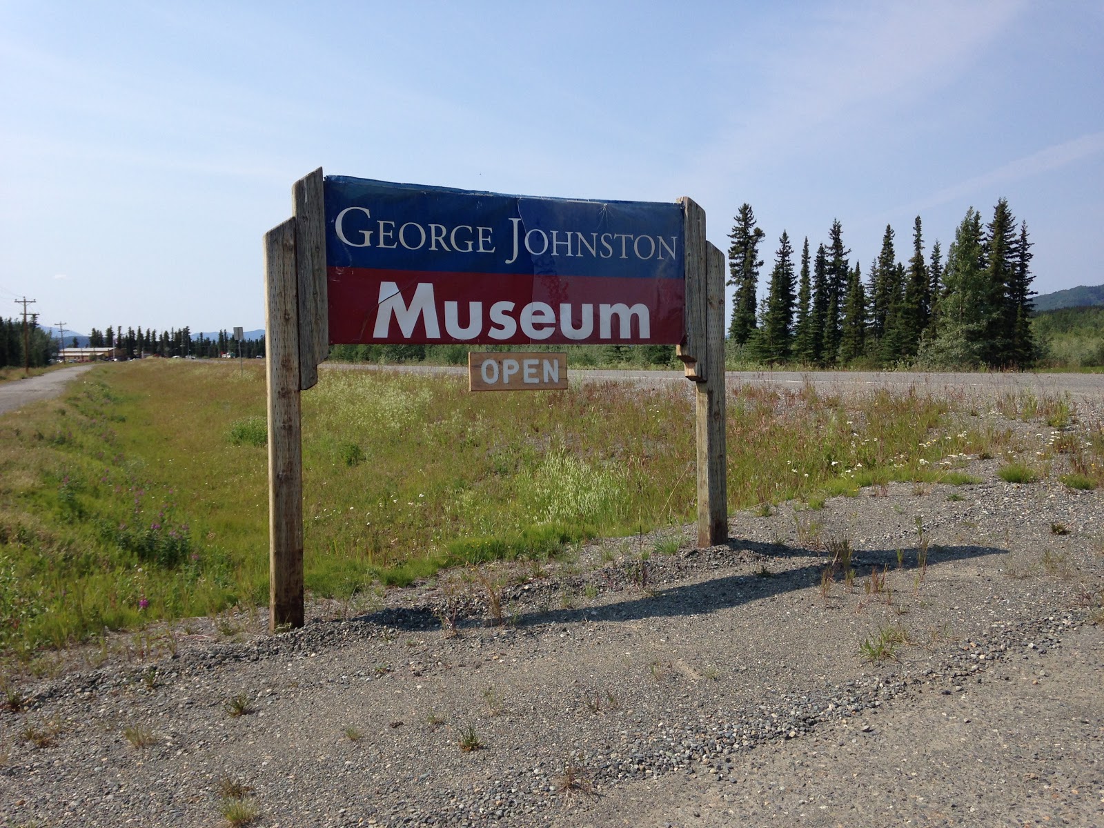
One of the attractions we visited was the George Johnston Museum.  We decided to walk to the museum from our campground which was located on the lake.
On our way,  a man jumped out of his truck and ran towards us alerting us that there was a black bear on the road coming from the museum.  We were about to cross the street when we spotted the bear doing just that…he was crossing over the highway which meant that we could continue on our way.
Talk about being lucky…I don’t even want to think about what would have happened if we confronted this bear….I’m glad we are safe!
Back to the museum….
The museum tells the story of the venerated Tlingit elder, photographer, trapper, and entrepreneur George Johnston.  George left a rich legacy of historic photographs that captured almost every aspect of life in the Teslin area…he preserved the Tlingit community and its cultural changes.
George also brought the first automobile to the area even though there were no roads…..but the frozen Teslin Lake offered 78 miles of highway to drive on….he painted the car white in the winter to camouflage it on the lake where he fished and trapped animals.  He also provided taxi service for the community and hired local people to help him widen the trails around Teslin and to cut a five mile road to Fox Creek….this stretch of road later became part of the Alaska Highway.  Here are some fabulous pictures of his community and car.
What an amazing story!

Friday, July 27, 2018

Watson Lake

Our next adventure was the Watson Lake area….I have to say that we finally saw a lot of wildlife, particularly Bison.
We stopped at Historical Milepost 570, Allen’s Lookout….Legend has it that a band of outlaws took advantage of the sweeping view of Liard Lake to attack and rob riverboats. A cairn near the picnic area is dedicated to the surveyors of the Alaska Highway.
One of the famous places you have to visit is the Sign Post Forest….people from all around the world leave road signs, license plates, etc…..it is quite a sight to behold. Lee brought one our our old Motorcoach license plates to be added to this illustrious collection. We even found a road sign for Litchfield, Connecticut, Lee’s hometown!
Afterwards, we visited the Northern Lights Planetarium where we learned about Solar storms and the Aurora Borealis. It was fascinating and we hope to see some incredible skies along the way.
We then headed to our campground which offered us a place to stay, but that is all I can say positive about it…..everywhere you went, there were signs of restrictions…..fines to be paid in the event of not heeding the warning….everything was soooo expensive….the site alone which was just 30 amp and water (no sewer) was $60 Canadian…..we ate dinner at their restaurant to make things easy and paid $25 for a burger….Both of us felt that you got less than you paid for considering the other campgrounds we have stayed out…oh by the way, the name of this campground is Baby Nugget RV Park….camper beware!

Liard River Hot Springs

The next day we headed out early……our destination, the Liard River Hot Springs! Today we finally saw mountains and wildlife.

One of the stops we made was at the Testa River Campground for their renowned cinnamon buns….I have to say they were wicked sweet so I’m glad we got a coffee to share while we sat at one of their outdoor picnic tables.
After getting our sugar quota for the day, we continued on our way…..we passed Summit Lake with fabulous mountain views. We passed through the MacDonald Bridge, the bridge and creek named after Charlie MacDonald who was a Cree Indian credited with helping Alaska Highway survey crews locate the best possible route for the highway.
We passed by Folded Mountains which were created by the continental shelf getting squeezed by the shifting of North America about 175 million years ago and the flat-lying areas underneath slowly buckling into folds. Over time, these areas sprang up into mountain ranges.
We passed by the beautiful Muncho Lake with its deep green and blue waters.
We finally arrived at the Liard Hotsprings…….we were able to dry camp across the road overnight, so once we got settled we headed over to experience what is one of the most favorite stops on the highway. It is the home to the largest natural hot springs in Canada…it is a natural river of hot water…it has a mineral content of more than 1000 parts per million…..a lot of it is calcium carbonate picked up from underground limestone….plus it has a wicked sulphur smell. You get to the springs by a boardwalk that was built over the marshlands that never freeze in the winter. Here are some pictures.
I have to say that it was a wonderful way to have a spa treatment!

Monday, July 23, 2018

The Triple "G" Hideaway in Fort Nelson

The next day we were back on the road….really nothing special to report…..the only scenery was the forests on either side of us…no mountains, no animal sightings….just flat land. The only thing that made this travel day special was arriving at the Triple “G” Hideaway Campground….what a hoot! Run by Mama D, this campground offered a family restaurant called the Saloon and a cute gift shop. We decided to go to the Saloon after dinner to check it out…..it was a cute little bar/restaurant with buffet service. We went and sat on the “saddle” seat bar stools and shared a hot fudge sundae.
We met Mama D in the gift shop section of the Saloon whereupon she said that she got a kick out of our last name! Thanks Mama D!

Dawson Creek continued

Another self guided walking tour we took was at the Walter Wright Pioneer Village….Walter Wright, longtime resident and businessman of Dawson Creek, had a vision of creating a collection of buildings, historic replicas, artifacts, vintage vehicles and farm machinery to tell the story of the area’s first settlers. We visited the old school house, fire hall, log homes, telegraph and telephone exchange, doctor’s office, Anglican Church, barber shop, and general store. Here are a few pictures!
Afterwards, we hit the road...next destination The Triple "G" Hideaway in Fort Nelson!

Dawson Creek - Mile 0 of Alaska Highway

When you first get to Dawson Creek, you have to take a very famous picture....so here it is!
Afterwards, we decided to take a self guided historic walking tour of the downtown.
What a great time we had exploring the past and the present of this town with all the plaques and murals depicting what the community looked like back in the day contrasted with what exists now.
There were beautiful murals depicting famous people as well as historic moments.
One of the people we met along the way was a young man, Clarence Paterson. We were just schmoozing and before you knew it, we were talking for at least 45 minutes. Clarence and his wife are expecting their first child....He owns his own business, Paterson Industries, which specializes in facility construction, maintenance, and service (that's a little plug for you Dahling!)....they love to travel and might make it up to Maine for some hunting! We exchanged phone numbers and, of course, my blog information….perhaps we might meet again in the states.
Another thing we did was visit the Alaska Highway House which is a museum chronicling the history of the building of the highway…I bet you didn’t know that this Canadian Alaska route was built right after the US was attacked by Japan in World War II…..Alaska and the west coast were extremely vulnerable…..We needed a way to get military supplies and troops to Alaska and ensure the defense of North America…..thus the idea of the highway from Dawson Creek to Fairbanks, Alaska….1523 miles!. The Army Corp of Engineers and about 11,000 enlisted men worked on the pioneer road….the conditions were horrendous both in the summer and winter for the men. They were required to build this road in less than a year and they accomplished it in 8 months. In 1954, the Historic Sites and Monuments Board of Canada recognized the Alaska Highway as an Event of Historic Significance. In 1996, the Alaska Highway was designated as the 16th International Civil Engineering Landmark by the Canadian Society for Engineering and the American Society of Civil Engineers.
We had a pretty busy day!